
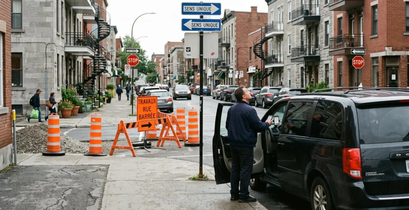
A downtown Montréal destination might be only three kilometres away, yet reaching its entrance by car can involve one-way streets, construction barriers, restricted stopping zones and unexpected detours. The shortest distance on a map rarely tells the whole story of an urban journey.
City-specialized transportation addresses these complications by planning beyond the GPS estimate. The important decisions include which streets actually provide access, where passengers can legally and safely board, whether a major event changes the surrounding road network, and how much time to reserve for potential disruptions.
These considerations affect visitors heading to appointments, residents arranging group transportation, travellers carrying luggage and households organizing moves. A suitable vehicle and a realistic route can matter more than the apparent directness of the journey.
The objective is not to promise that every traffic jam can be avoided. It is to identify predictable obstacles, compare reasonable alternatives and prevent a minor street restriction from becoming an expensive scheduling problem.
Montréal city transportation: essential decisions
- Verify one-way access, municipal construction restrictions and provincial highway conditions before relying on a GPS arrival estimate.
- Compare the complete cost of parking against round-trip passenger transportation, including walking, waiting and possible delays.
- For festivals, large groups, mobility requirements and moves, confirm the vehicle, legal stopping location and pickup arrangements before departure.
- Why Your GPS Added 12 Minutes: The One-Way Street Trap in Downtown Montréal’s Grid
- How to Navigate Montréal’s April-November Construction Season Without Adding 40 Minutes to Trips
- 28 𝑃𝑎𝑟𝑘𝑖𝑛𝑔 𝑣𝑠. 28Parkingvs.45 Drop-Off and Pickup: The Break-Even Point for 3-Hour Downtown Appointments
- The Festival Mistake That Turned a 15-Minute Ride Into a 50-Minute Detour in Summer
- When to Schedule City Transportation: Avoiding Montréal’s Peak Congestion Windows
- 18.6 How to Select Passenger Transportation That Accommodates Mobility, Luggage, and Group Needs
- 18.7 How to Bypass Décarie, Ville-Marie, and Turcot: Alternative Routes That Save Real Time
- 18.8 Bell Centre vs. Place des Arts: Which Venue’s Situation Makes Drop-Off Worth It?
Why Your GPS Added 12 Minutes: The One-Way Street Trap in Downtown Montréal’s Grid
Montréal’s downtown one-way streets can turn a missed intersection or unexpected closure into a multi-block detour. A GPS may calculate the correct legal route but still underestimate delays from traffic signals, turning restrictions and congestion around the destination. The practical solution is to verify the final approach and stopping location before travelling, rather than relying exclusively on the displayed arrival time.
Unlike a simple two-way road network, a grid containing numerous one-way segments limits opportunities to correct a missed turn. Reaching an address on the opposite side of a block may require circling several intersections. When another street is closed for construction, the available approaches become even more restricted.
Major corridors such as René-Lévesque Boulevard, Sherbrooke Street and Saint-Antoine Street illustrate why the direction of travel, turning permissions and destination access must be considered together. Their traffic patterns differ, and their intersections cannot be treated as interchangeable shortcuts.
A navigation application may respond to traffic conditions, but its forecast is only an estimate. Temporary lane restrictions, queues at intersections and an unsuitable suggested pickup point can change the result. Local street knowledge is useful when it identifies a better legal approach rather than merely a shorter-looking route.
For a time-sensitive trip, examine the destination from the passenger’s perspective. Identify the entrance, determine whether the vehicle can stop near it and check whether the final street segment is affected by works. An address that appears accessible on the map may require passengers to walk from an adjacent street.
A useful preparation method is to compare estimated journey times at the intended departure hour on comparable weekdays, then check the city’s construction information. Keep an alternative approach available, especially when the appointment cannot start late.
Passenger transportation and deliveries also require different routing decisions. A minivan dropping off two travellers needs a safe boarding location, whereas a truck carrying furniture may need access for loading, unloading and additional labour. A legal passenger stop does not automatically provide permission to occupy a street for a move.
Hypothetical example: the missed downtown turn
A passenger is travelling to an appointment near a one-way downtown street. A closure prevents the planned turn, requiring several extra blocks and another series of traffic signals. In this illustrative scenario, a journey initially estimated at 15 minutes takes 27 minutes.
The lesson is not that every Montréal detour adds 12 minutes. It is that checking the last few blocks of a journey can be as important as selecting the main corridor.
Street layout is only the first source of uncertainty. Construction restrictions can change the available routes after a familiar journey has already become routine.
How to Navigate Montréal’s April-November Construction Season Without Adding 40 Minutes to Trips
To reduce construction-related delays in Montréal, check current municipal street obstructions and provincial highway restrictions, identify alternative routes and confirm access again shortly before departure. Roadworks are especially visible during the warmer months, but their schedules and effects vary. No single preparation method can guarantee avoiding a 40-minute delay, particularly when incidents overlap with planned closures.
Spring through autumn is a useful period for heightened attention to street works, although Montréal construction activity is not confined to April through November. Road closures may begin, end or change configuration as projects progress. A road that was accessible last week may have reduced lanes or restricted turns today.
The city’s Ville de Montréal’s Obstructions and Construction Info service helps travellers identify construction-related obstructions using an interactive map. Its information draws on street occupancy permits and includes projects associated with different organizations.
Municipal information does not cover every provincial project or neighbouring municipality. Travellers using expressways or crossing into surrounding regions should also consult the Québec 511 interactive road conditions map, which distinguishes complete and partial closures and provides roadwork information.
Not every closure requires the same response. A complete expressway closure may require a substantial detour, while a weekend restriction might be avoided by changing departure time. Neighbourhood construction can be particularly disruptive when it prevents a vehicle from reaching the intended curb.
The distinction matters for accessible transportation and furniture moves. A passenger with limited mobility may need to be dropped off close to an accessible building entrance. A moving crew may need reserved street space rather than a brief stop near the address.
| Restriction | Likely planning issue | Practical response |
|---|---|---|
| Complete highway closure | Main route unavailable | Check an alternative corridor and its connections before departure. |
| Night or weekend closure | Access changes by time | Consider rescheduling when the appointment is flexible. |
| Local street construction | Destination approach affected | Confirm legal pickup and unloading points nearby. |
| Partial lane obstruction | Queue length uncertain | Allow additional time and reassess traffic before leaving. |
Construction can also redirect traffic onto secondary roads. A route that normally operates smoothly in the early afternoon may experience unexpected congestion when drivers avoid another corridor. Comparing current conditions matters more than relying on an assumed quiet hour.
Five checks before a construction-sensitive Montréal trip
- Identify the exact destination entrance. Record its street address and the intended legal drop-off location.
- Check municipal obstructions. Write down any construction restrictions affecting the origin, destination or connecting streets.
- Check provincial routes separately. Record relevant expressway closures or lane restrictions shown by Québec 511.
- Compare two workable alternatives. Save a primary route and a backup route, including their current estimated journey times.
- Reconfirm the travel plan. Before departure, verify restrictions, pickup details and the latest acceptable arrival time.
Even when roads remain accessible, travellers face another practical decision downtown: whether finding and paying for parking is more sensible than arranging a passenger drop-off.
28
𝑃
𝑎
𝑟
𝑘
𝑖
𝑛
𝑔
𝑣
𝑠
.
28Parkingvs.45 Drop-Off and Pickup: The Break-Even Point for 3-Hour Downtown Appointments
For a three-hour downtown Montréal appointment, parking is financially preferable when its total cost remains below the complete round-trip transportation cost, after accounting for vehicle expenses and the value of time. A hypothetical comparison of $28 parking against $45 for transportation favours parking by $17 before other factors. The actual decision depends on location, fares, parking availability and the journey involved.
Comparing a parking fee with a single transportation fare is misleading when the passenger also needs to return home. Two separately charged rides can substantially change the calculation. Conversely, if the quoted $45 genuinely includes both drop-off and pickup, that total becomes the appropriate comparison.
Montréal provides Montréal’s maps of paid on-street parking, including hourly charges and applicable payment periods. These municipal maps do not display space availability in real time and do not establish prices for private indoor parking garages.
Before selecting a paid parking space, distinguish posted rates from total cost. A three-hour appointment can require more than three hours of parking when walking time, building access, queues and unexpected waiting are included.
The relevant calculation is straightforward:
Total self-parking cost = parking charges + additional driving expenses + valued parking-search and walking time + applicable expected risk costs.
Total passenger transportation cost = all booked fares + applicable fees + valued waiting and walking time.
Hypothetical comparison: a three-hour downtown appointment
Assume parking costs $28 and a confirmed round-trip passenger service costs $45. The direct price difference is $17. If parking and reaching the appointment take an additional 25 minutes, the effective decision depends on how the traveller values those minutes.
At a hypothetical personal time valuation of $24 per hour, 25 minutes represents $10. Parking would then have an illustrative combined cost of $38, still below the $45 transportation option. This calculation excludes other driving expenses and uncertain penalties; none of these figures represents a verified Montréal market quote.
Parking becomes less appealing when the driver risks spending considerable time searching for a legal space or leaving a crowded garage after an event. Parking fines or towing can create additional exposure if restrictions are misunderstood, although their likelihood and cost should not be assumed without relevant information.
Drop-off is not automatically preferable. Someone attending several appointments across the city may benefit from keeping a vehicle available. An individual travelling with multiple passengers may also find that one parking fee compares favourably with several passenger transportation fares.
Accessibility changes the decision again. A conveniently located garage may still involve a lengthy walk or a difficult entrance, while a prearranged accessible drop-off can reduce physical demands. The appropriate choice depends on the actual journey from curb or parking space to destination.
This approach works for ordinary appointments, but concerts and summer festivals introduce additional restrictions that can outweigh a small difference in transportation price.
The Festival Mistake That Turned a 15-Minute Ride Into a 50-Minute Detour in Summer
During Montréal’s summer events, the principal transportation mistake is planning for normal vehicle access to a destination inside or beside a restricted festival perimeter. Street closures, pedestrian concentrations and designated access points can invalidate an otherwise reasonable route. A successful plan considers the event’s official access arrangements, a safe drop-off location and the return journey before the event begins.
Montréal’s Quartier des Spectacles, Old Port and Parc Jean-Drapeau attract substantial event-related activity. Festivals such as the Montréal International Jazz Festival and Osheaga bring large audiences into areas where street access, pedestrian movement and transportation demand can differ from an ordinary weekday.
A closure around a festival does more than remove one road from the map. It may restrict turning movements, concentrate traffic at a limited number of intersections and prevent vehicles from stopping near the intended entrance. Even when a GPS identifies an alternate road, that road may not provide useful access to the final destination.
Before travelling, check the event organizer’s access information and applicable official street notices. Look for pedestrian-only areas, recommended arrival locations and changes to vehicle circulation. Recheck the details near the event date because temporary arrangements can evolve.
A practical tactic is to choose a legal stopping location outside the most crowded area, provided the walking route is appropriate for the passengers. An adjacent street is not necessarily available: it may have its own stopping restrictions or restricted access.
The return journey often deserves greater attention than the arrival. Many spectators leave shortly after the same performance ends, creating intense demand for taxis, rides and other transportation. A vague pickup instruction such as “outside the venue” leaves passengers and drivers searching for each other.
Instead, choose a precise, accessible meeting address outside the restricted perimeter, communicate it to everyone travelling and agree on how to handle delays. When appropriate, allow some time after an event ends before requesting pickup.
Hypothetical festival access problem
A group books transportation based on a normal 15-minute route to a downtown festival. Shortly before arrival, access restrictions force the vehicle onto crowded surrounding streets. In this illustrative scenario, the complete journey takes 50 minutes.
A better plan would have identified an approved approach, a legal drop-off point and a realistic walking connection. The example illustrates a possible scheduling failure, not a documented incident or a typical festival delay.
Event planning is one application of a wider scheduling principle: the same Montréal streets can behave very differently depending on departure time, direction and surrounding activity.
When to Schedule City Transportation: Avoiding Montréal’s Peak Congestion Windows
Montréal transportation is generally easier to schedule when travellers avoid the busiest commuting periods, particularly the morning and late-afternoon peaks. Approximate planning windows include 7–9 AM and 4–6 PM, with possible lunchtime congestion around noon. These are tendencies, not guaranteed traffic forecasts. Construction, weather, events and the direction of travel can shift the best departure time considerably.
Morning congestion often affects routes leading toward employment centres, while evening traffic can intensify on outbound approaches and crossings. These directional patterns are useful starting points, but they cannot replace a journey-specific estimate.
Bridges such as Jacques-Cartier, Samuel-De Champlain and Victoria create additional constraints for travellers moving between Montréal Island and the South Shore. A problem at a bridge approach may affect nearby roads even when the final downtown destination is far from the crossing.
For flexible appointments, test departures roughly one hour before or after the expected peak. Compare the complete door-to-door journey, not just time spent in the vehicle. An earlier departure that creates an unnecessarily long wait may not improve the overall experience.
For fixed appointments, work backward from the required arrival time. Include the time needed to enter the building, handle luggage, walk from the drop-off point and accommodate a reasonable traffic buffer based on the journey’s uncertainty.
| Period | Potential challenge | Planning response |
|---|---|---|
| 7–9 AM | Morning commuting and inbound traffic | Compare earlier departures and check major approaches. |
| 12–1 PM | Localized lunchtime demand | Check destination-area traffic rather than assuming a citywide peak. |
| 4–6 PM | Evening commuting and outbound queues | Test later departures and allow for bridge approaches. |
| Summer Thursday and Friday afternoons | Potential overlap of commuting, departures and construction | Recheck actual conditions and avoid relying on normal weekday assumptions. |
Different journeys also have different tolerance for congestion. A passenger heading to a flexible social visit may accept a slower ride, while someone catching a flight must plan around a fixed deadline.
Large luggage loads and furniture deliveries introduce an additional consideration: a vehicle may reach the address on time yet be unable to unload efficiently. Scheduling outside busy periods may help, but legal access and any required street occupancy permission remain essential.
Once the departure time is settled, the next decision is whether the selected vehicle can safely accommodate the passengers, belongings and physical access requirements.
18.6 How to Select Passenger Transportation That Accommodates Mobility, Luggage, and Group Needs
Choosing suitable passenger transportation in Montréal requires separate checks for accessibility, luggage volume and passenger capacity. A vehicle with enough seats may still lack adequate cargo space, and a large vehicle is not necessarily wheelchair-accessible. Confirm the actual configuration, boarding requirements, assistance services and pickup location with the provider before booking rather than assuming that a vehicle category guarantees suitability.
Accessibility comes first when a passenger uses a wheelchair, cannot climb steps comfortably or requires assistance entering and leaving a vehicle. Ask whether the assigned vehicle supports the person’s specific needs, including any required ramp or lift, securement equipment and assistance.
For luggage, count both items and approximate dimensions. Several large suitcases, mobility equipment or sports gear may exceed the practical storage capacity of a vehicle that nominally accommodates all passengers. Seats should not be assumed available for luggage when they are needed for people.
Groups also need to distinguish advertised passenger capacity from usable capacity. A larger vehicle may accommodate the required number of passengers but leave insufficient room for substantial baggage. Confirm the proposed seating and luggage configuration rather than relying on the model name alone.
Booking multiple smaller vehicles can provide flexibility, but it can also complicate coordination. Vehicles may arrive at different times, use different pickup locations or become separated in traffic. A single suitable vehicle may simplify the journey when availability and total cost make sense.
Montréal’s residential architecture adds a different challenge to moves and large-item transport. Exterior staircases, tight entrances, narrow streets and buildings without elevators can make loading and unloading difficult even when the vehicle itself is adequately sized.
Moving vehicles may also face municipal street occupancy requirements. Depending on the borough and circumstances, operators may need authorization to reserve curb space, occupy paid parking spaces or implement temporary restrictions. The Ville de Montréal’s moving truck parking requirements describe borough-specific procedures and applicable conditions.
These requirements should not be confused with those for ordinary passenger drop-offs. A moving truck occupying street space for an extended period creates different access and safety considerations from a vehicle stopping briefly to allow passengers to exit.
Before confirming transportation, request written information identifying the number of passengers, luggage requirements, vehicle accessibility, assistance included, destination entrance and agreed pickup location. For a move, also specify large-item dimensions, stairs and any expected street occupancy arrangements.
When accessibility is essential, written confirmation provides a useful record of what the provider has agreed to supply. It does not replace verifying the details of the specific vehicle and service being dispatched.
With the right vehicle established, route selection becomes the next opportunity to avoid delays, particularly around Montréal’s busiest expressway connections.
18.7 How to Bypass Décarie, Ville-Marie, and Turcot: Alternative Routes That Save Real Time
There is no universally faster alternative to Montréal’s Décarie, Ville-Marie and Turcot corridors. The effective bypass depends on the origin, destination, current closures and traffic conditions. A surface street may outperform an expressway during a specific incident, but frequent traffic signals and diverted vehicles can eliminate the advantage. Compare complete routes in real time instead of assuming that one particular detour always saves time.
Autoroute 15 through the Décarie corridor, Autoroute 136 along the Ville-Marie axis and the Turcot interchange are important components of Montréal’s central highway network. Their connections influence access between western approaches, downtown and other parts of the metropolitan area.
When a restriction affects one of these routes, its consequences can extend beyond the closed segment. Drivers searching for alternatives may increase demand on adjacent interchanges and surface streets. A bypass that initially looks attractive can deteriorate as traffic redistributes.
The first routing question is whether the journey genuinely requires crossing the affected area. A trip between two destinations on the same side of a congested corridor may be better served by remaining on local roads, whereas a longer trip may still benefit from the highway despite a temporary queue.
Surface alternatives require careful geographic selection. Saint-Jacques Street can be relevant to some east-west movements. Côte-des-Neiges Road serves different north-south connections, while Saint-Laurent Boulevard has its own urban access characteristics. They are not interchangeable replacements for the same expressway journey.
For drivers entering or leaving Montréal Island, bridge selection and the approach to that bridge may matter more than avoiding a particular downtown ramp. A longer bridge crossing route is not automatically quicker simply because its immediate traffic appears lighter.
When comparing alternatives, evaluate the estimated time from the actual origin to the actual destination. Include additional turns, traffic lights, one-way restrictions and the final approach. For larger passenger vehicles, account for permitted access and safe stopping locations as well.
A time saving of 22 minutes is possible as a hypothetical outcome in particular conditions, but it is not a verified or repeatable performance figure for Montréal route alternatives. The useful measurement is the difference between the current complete-route estimates, checked again before committing to a diversion.
Professional local knowledge is most valuable when it complements current official restrictions and navigation information. Familiarity with intersections, road widths and suitable stopping points helps assess whether an algorithmically proposed alternative is practical.
Route optimization becomes particularly important when a large event creates both predictable traffic demand and difficult final access, as illustrated by two prominent downtown venues.
Key decisions before choosing event transportation
- Compare parking against the full round-trip transportation cost, not a single fare or an isolated hourly rate.
- Check the venue’s actual entrance, accessible access arrangements and event-related street restrictions before choosing a drop-off.
- Decide where passengers will reunite after the event, accounting for crowd movement and possible temporary traffic controls.
18.8 Bell Centre vs. Place des Arts: Which Venue’s Situation Makes Drop-Off Worth It?
Drop-off can be preferable at both Montréal’s Bell Centre and Place des Arts, but neither venue makes it universally cheaper or more convenient than parking. Bell Centre access is influenced by its dense downtown location and event traffic, while Place des Arts can also be affected by festival-related restrictions in the Quartier des Spectacles. The deciding factors are parking availability, total transportation cost, accessibility and the post-event pickup plan.
Bell Centre is situated in a highly developed downtown environment, where major events can concentrate vehicles and pedestrians around surrounding streets, including Saint-Antoine Street and Avenue des Canadiens-de-Montréal.
Driving allows passengers to choose among available parking arrangements, but the relevant garage price, permitted entry, walking distance and expected exit process should be checked for the particular event. A nearby garage may still involve queues or a busy pedestrian approach.
Bell Centre also benefits from access to the Montréal metro network, including the nearby Lucien-L’Allier and Bonaventure stations. For some travellers, public transit can remove parking from the equation entirely.
Place des Arts occupies a different urban setting within the Quartier des Spectacles. Nearby streets may be affected by temporary festival configurations as well as ordinary downtown traffic. Its relationship with Place-des-Arts metro station makes rail access worth comparing with both driving and private passenger transportation.
For either venue, the cost calculation changes with group size. One parking fee shared by several people can be attractive, while a group needing two separate vehicles may face a very different transportation total. Passengers with limited walking ability may place greater weight on accessible drop-off arrangements.
The comparison should also include the return journey. A vehicle dropping passengers near the venue before the performance may not legally or practically be able to collect them at that same point afterward.
| Decision factor | Bell Centre | Place des Arts |
|---|---|---|
| Primary local challenge | Dense downtown access and event-related congestion | Downtown access combined with potential festival street restrictions |
| Parking decision | Confirm garage pricing, availability and exit arrangements | Check nearby parking options and any temporary access changes |
| Metro alternative | Lucien-L’Allier and Bonaventure | Place-des-Arts |
| Drop-off assessment | Confirm a suitable stopping location near the relevant entrance | Check pedestrian restrictions and the available vehicle approach |
| After-event pickup | Choose a precise location outside the busiest exit area | Select a meeting location compatible with event restrictions |
| Accessibility | Confirm suitable entry and transportation assistance | Confirm accessible entry and the best arrival arrangement |
The most practical decision can differ for two people attending the same event. A solo visitor staying near a metro station may find rail travel easiest. A family with luggage or a passenger requiring specialized transportation may prefer a prearranged vehicle, provided the access arrangements are confirmed.
Neither private transportation nor parking eliminates congestion. A drop-off can reduce the need to find a space, but it still requires a legal curb location and may encounter the same busy approaches as other traffic.
For the next Montréal event or appointment, confirm the entrance, compare complete transportation costs, check active road restrictions and communicate one precise pickup plan. Those four decisions provide a practical foundation for navigating the city without depending on an unrealistic promise of traffic-free travel.
Can Montréal’s official construction maps replace a GPS application?
No. Montréal’s municipal obstruction information identifies relevant construction restrictions, while Québec 511 covers important provincial road-network conditions. GPS applications serve a different purpose by estimating routes and journey times. Using these resources together provides a more complete basis for planning, although none guarantees an uninterrupted trip.
Should visitors rent a car for a short stay in downtown Montréal?
Not necessarily. Visitors staying near metro stations and walking-distance attractions may find public transit and occasional passenger transportation more practical than paying for a rental vehicle and parking. A rental car can be more useful for frequent journeys outside well-served areas. Compare the entire itinerary before deciding.
How can travellers confirm whether a pickup location is legal?
Check posted stopping and parking signs, temporary restrictions and any relevant event access instructions. A provider should confirm that the proposed pickup is suitable for its vehicle and service. Do not assume that an address suggested by a navigation application permits stopping at the curb.
Does a larger vehicle automatically accommodate wheelchair users or oversized luggage?
No. Passenger seating, luggage volume and accessibility are separate requirements. Confirm the specific vehicle’s usable storage space, boarding configuration, necessary wheelchair equipment and available assistance before making a reservation.
What should travellers do when a planned Montréal route closes unexpectedly?
Use current traffic and road restriction information to identify a legal alternative, then verify that the revised route still reaches an appropriate entrance or drop-off point. If arrival will be delayed, inform the destination or other passengers. Avoid making unsafe turns or entering restricted streets to recover lost time.